Spring High Water, Map Elevations, and Tidal Wetlands
From Titus and Wang (2008)
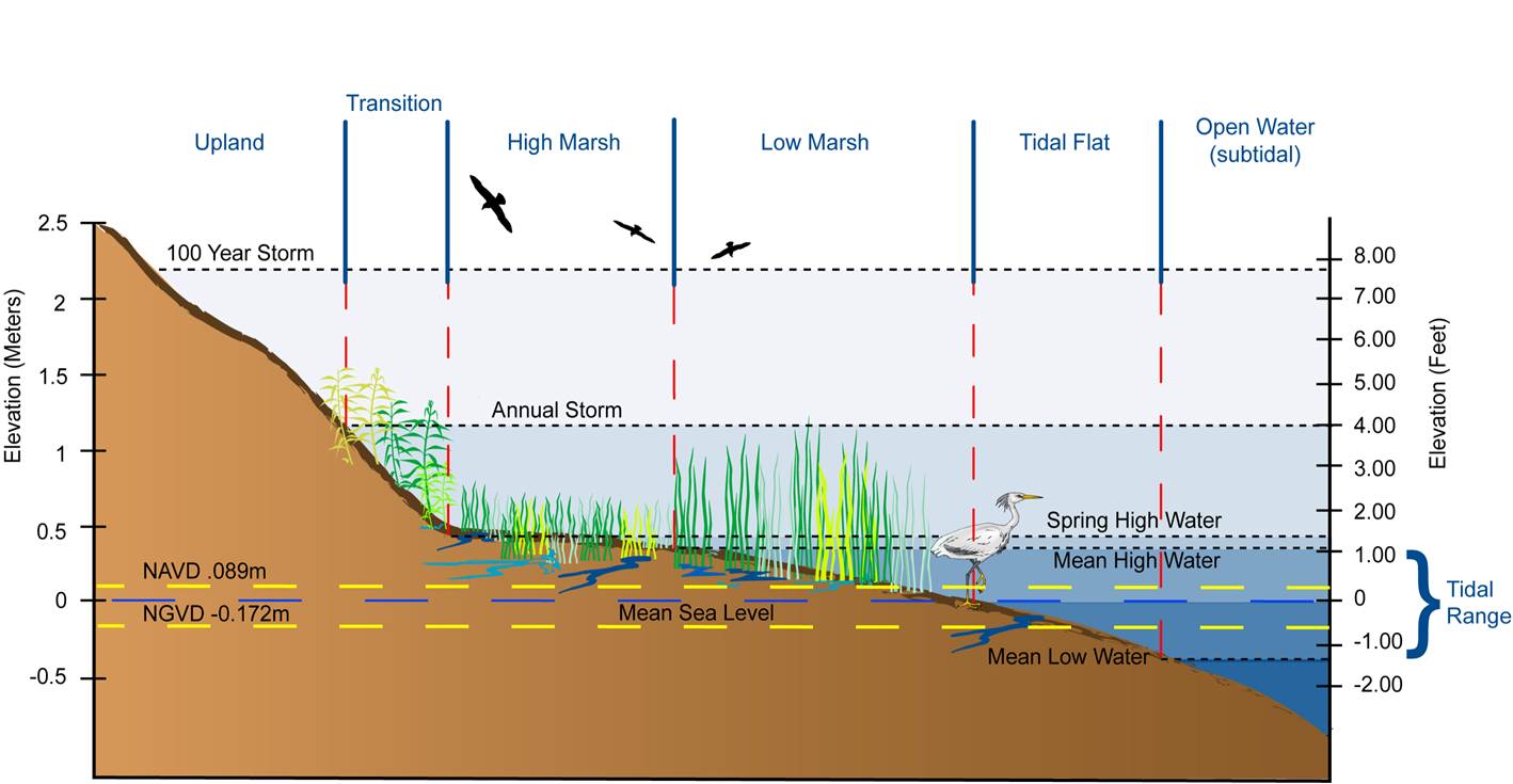
Tides are caused by the gravitational attraction of the moon and sun on the ocean water. Most places in the mid-Atlantic region have two high and low tides every day. The daily tide range varies over the course of the lunar month. Mean high water and mean low water are the average elevations of the daily high and low tides. During full and new moons, the gravitational pull of the moon and the sun are aligned, which causes the tide range to be 15-25% greater than average. The average of the full and new moon high and low tides are known as spring high water and spring low water. In addition to the astronomic tides, water levels fluctuate due to winds, atmospheric pressure, ocean current, and--in inland areas-river flow, rainfall and evaporation. Daily tide ranges in the mid-Atlantic are as great as eight feet in parts of the Delaware River and only a few inches in some of the sounds of North Carolina.
In coastal areas with tidal marshes, the high marsh is generally found between mean high water and spring high water, while low marsh is found from slightly below mean sea level up to spring high water. (See diagram.) In bays with small tide ranges of about half a foot (10-20 cm), however, winds and seasonal runoff can cause water level fluctuations with a greater impact on tidal wetlands than the tides themselves. These areas are known as "irregularly flooded". In some locations, such as upper Albemarle Sound in North Carolina, the astronomic tide range is essentially zero, and all wetlands are irregularly flooded. Freshwater wetlands in such areas are often classified as "nontidal wetlands" because there is no tide, but unlike most nontidal areas, the flooding-and risk of wetland loss-are still controlled by sea level. Wetlands that lie at sea level along an estuary with a very small tide range are more accurately called nanotidal wetlands
Tide gauges measure the water level relative to the land, and thus include both changes in the elevation of the ocean surface and movements of the land. For clarity, scientists often use two different terms. Global sea level rise is the worldwide increase in the volume of the world's oceans that occurs as a result of thermal expansion and melting ice caps and glaciers. Relative sea level rise refers to the total change in sea level relative to the elevation of the land, which includes both global sea level rise and land subsidence.
Land elevations are measured relative to either water levels or a fixed reference plane. Most topographic maps use one of two fixed reference elevations. USGS topographic maps measure elevations relative to the National Geodetic Vertical Datum of 1929 (NGVD29), which is a fixed reference "plane" adopted as a standard reference, based on elevations in the year 1929. NGVD29 was derived by estimating sea level at a set of 26 locations in the United States and Canada, and then surveying a reference plane between those locations. NGVD29 is no longer the official reference elevation. Newer digital elevation maps and high-resolution data generally measure elevations relative to the the North American Vertical Datum of 1988 (NAVD88).
Source: Titus and Wang (2008)